Managing Water Resources in Kenya's Upper Tana River Basin
Helping stakeholders in the Tana River region manage water resources
• Data Analysis
• Climate Informatics
• Resource Management

Project Background: Senior practicum project at UCLA
Advisor: Edith DeGuzman
Team Members: Myself, Ahmed Elauri, Sonia Aronson, Andrew Johnson, Liam Maxwell, Adriana Rangel, Nikki Zhang
Clients: IBM, The Nature Conservancy (TNC)
Read Our Final Report Here
Watch Our Final Project Presentation Here
We partnered with IBM and The Nature Conservancy (TNC) to develop an open water data platform that helps stakeholders in the Upper Tana River Basin better understand and manage water resources.
We built upon work done by TNC to create a platform that will be easy for government officials and water managers to access and use, allowing local stakeholders to make informed water management decisions.
We gathered and analyzed publicly available water quality data and socioeconomic characteristics to explore relationships between environmental and social factors that may affect water availability in the area.
The final deliverables of our project offer a simple and effective user experience and will shed much-needed light on the increasing issues of water scarcity and degraded quality in a changing climate.
Goals:
• Understand changing water resource conditions in the Upper Tana Basin
• Provide insight on the efficacy of TNC interventions as the Water Fund transitions to independent management
• Collect and analyze data relevant to evaluating water quality and quantity
KEY FINDINGS:
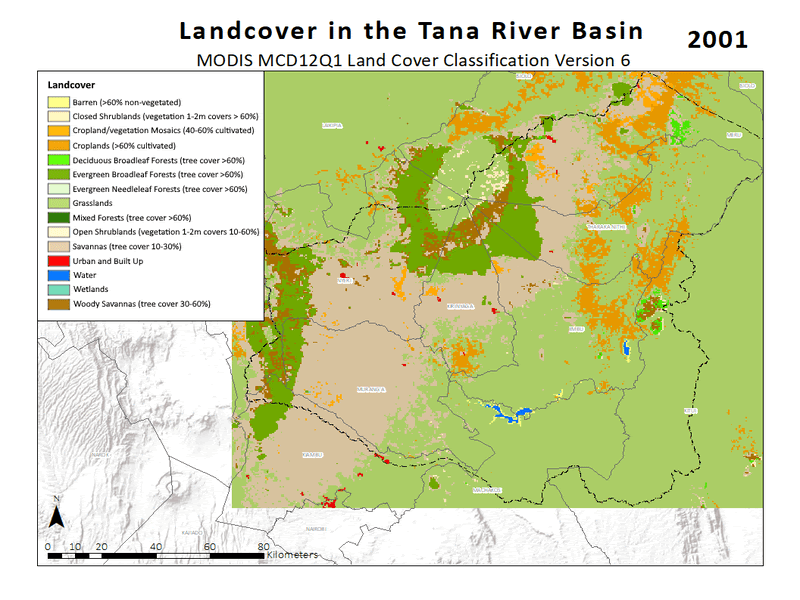
1. Land Cover Change
Land cover data from the MODIS, Sentinel, and Copernicus datasets was obtained for various years in the period between 2000-2019.
Land cover does not change drastically over the time period from 2001 to 2019. Forest and cropland cover about the same amount of area.
Soil moisture was investigated to provide insight on how land cover affects land surface parameters and water availability and quality in general for the region.
For all of the depths analyzed (0 to 10 cm, 10 to 40 cm, and 40 to 100 cm), areas with more forest cover have a higher soil moisture content. Additionally, soil moisture seems to moderately increase at greater depths.
Comparing land cover with surface runoff can also provide insight on erosion and water quality in the region.
When looking at the general trend of surface runoff over time, surface runoff seems to be increasing, indicating there may be an increase in erosion leading to worsening water quality.
However, variation in the amount of runoff each month also seems to have increased, which could be related to factors other than land cover change, such as the increased variability in precipitation.
2. Effects of Climate Variability
Kenya has two wet seasons called the long rains (March - May) and short rains (October - December). The measurements of precipitation remain relatively constant in similar seasons for the 1980-1985 period. For the 2015-2019 period, while the dry and rainy seasons did not necessarily shift from the 1980-1985 period, the magnitude of rain events during the wet seasons have likely increased, which may be attributed to global climate change. This is hypothesized to not affect the amount of rainfall but rather increase the severity of storms in shorter periods of times. There is a significant difference in precipitation levels for the five-year periods of 1980-1984 and 2015-2019.
Exploring the correlation between precipitation and soil moisture in the Upper Tana River Basin can provide insight on how changes in precipitation from climate variability may affect soil moisture and in turn agricultural production. Greater amounts of precipitation will increase soil moisture, but effects of precipitation will vary depending on temperature.

3. Efficacy of TNC Water Management Interventions
Two micro watersheds without interventions (Karuruumo and Thika Valley) and two watersheds with interventions (Githambara and Mbogiti) were studied in depth. Micro watersheds with implemented interventions showed improvements in water quantity (water level) and quality (total suspended solids and turbidity) compared to the control watersheds, and the interventions seem to be effective in improving water resource conditions. However, further analysis is needed to fully attribute these improvements to the interventions. Collecting data more regularly along with having on-the-ground verification of satellite data would strengthen the analysis of interventions and water conditions in the Basin. While no large changes in land cover were observed, precipitation has changed significantly in the past decades, confirming anecdotal concerns about the effects of a changing climate on agriculture. Sustainable adaptations can help stakeholders in this region weather changes in conditions.

MY ROLES:
Project Manager: Managing communication between the team, advisor, and clients; Organizing task and meeting logistics; Facilitating meetings; Creating meeting agendas and taking notes; Managing any internal conflicts
Data Analyst: Procuring and managing data; Evaluating best platforms for technical tasks (Statistical Analysis, Modeling, GIS); Collecting and documenting code; Ensuring final technical products are presentable and clearly understood
DELIVERABLES:
| DELIVERABLE | DESCRIPTION |
|---|---|
| Communcation Products |
Final Report:
Research findings/trends and comparison with outside sources • Describe the implications, future recommendations, and limitations of the project • Visualizations of quantitative/qualitative findings through graphics and maps • Annotated bibliography of literature sources relevant to watershed management in the Tana River region ArcGIS Story Map: Simple to use, interactive web-based storytelling products presenting data & findings for our clients. • Presentation of current status, impact of interventions, future projections Shiny Web Application: An interactive website, presenting data and findings on effectiveness of TNC interventions • Consists of a server R script and a UI R script. Clients can easily modify the website content by changing the R script. |
| Hydrological Assessment |
• Analyze water flow data to determine change in water availability of the basin based on micro-watersheds • Use discharge to compare the basin’s hydrological characteristics before and after TNC intervention • Use soil moisture to analyze hydrological characteristics of specific sub basins • Compare control and intervention sites, as well as changes within sites pre and post TNC intervention • Create models and graphs describing the findings and statistical significance |
| Conceptual Model |
• A flow-chart type model for overall understanding of the watershed • Provides inputs and outputs within the watershed |
| Climate Variability Projections |
• Clear figures representing the changes in precipitation in recent years • Projections on precipitation and climate change; providing perspective on what farmers should expect in the near future • Created using The Weather Channel data and spatio-temporal temperature and precipitation data |
| Land Cover Maps |
• Analysis of satellite data to determine change in land characteristics of the basin based on land use change over time • Annual land cover maps for 2001-2019 using the MODIS MCD12Q1 Version 6 IGBP land cover classification scheme, 463x463m resolution resampled to 30x30m resolution • Sentinel-2 MSI land cover map for 2016; Copernicus GCLS version 3 land cover maps for 2015-2019 • Copernicus CGLS land cover maps for a 100 meter buffer area surrounding the Githambara and Karurumo watersheds |
| Code Repository |
• Create a centralized online platform with relevant open source code and open access data to ease sharing capabilities (on both IBM CloudPak and GitHub ) • Use remote sensing (LandSat, Sentinel 2 &3) and machine learning to fill data gaps in client database • Python/R scripts to record methodology and meaningful insights for future reference • Create easily updatable dashboards that can be displayed publicly |
| Data Dictionary |
• A collection of sources and datasets used to develop our code and geographical products • Dataset information includes: Datapack name, dates of relevance, uses, and file type • Provides transparecy with our data and encourages replicability of our work as well as the verification of our findings regarding the efficacy and implications of TNC interventions |
Final Report ArcGIS Story Map Shiny Web Application
UCLA Web Page GitHub Repository
View Presentation Here